Hi All,
In April I acquired 4.5 acres of dry rain fed land in coastal andhra. This has red soil and red soil+sandy mix at some areas. The land slopes from north to south.
The two main tasks I need to do before starting any agriculture on this land are fencing( grazing cattle) and borewell/openwell.
Now coming to water, I am inclined to go for open well (which costs a lot) but can depend on manual or other forms of energy than grid-power. My father insists that bore well is a must. I have some questions and some stories to tell, but the focus of this thread is to know the ‘experiences’ of people using Water divining versus Geologist services to locate bore well point.
Questions:
What are the major advantages/dis-advantages with borewell versus openwell?
I learnt that the water that we pump up from borewell is from deep aquifers which could be really old as water travels very slowly in deep earth layers. It could either be good or not so good being contaminated with excess salts, fluorides etc (depending on depth). Whereas water from open wells is much newer and does not contain too many contaminants and recharge is good.
Today I read an article about how open wells are revived due to arsenic poisoning in bore wells. Read it here thebetterindia.com/11897/ars … ing-wells/
Can anyone explain how good yielding borewells supply so much water from a really tiny narrow borewell? Is there so much water flowing under?
What is a rig bore well and normal bore well?
Locating water.
First I will tell what I heard from first hand experience.
My close friend and colleague who is also interested/into in farming narrated one experience of water divining in his uncle’s farm. One fine day when these people were discussing about bore well in their farm, one man walked in from the nearby hills and said he could locate water. He selected a point which when approached, he would sit in a ‘gamla’ like the one used for cement and it would rapidly spin and throw him off balance. They got excellent water there.
Recently I got in touch with a female IT engineer who moved rural (near my farm area), works from home and also started her farming venture. She said she located the bore points herself with coconut. She vouches that there is some thing which really makes the coconut stand up in the palm. And it works.
Another female farmer close to my farm (returned from IT in US), featured on TV and whom I know for 1.5 years, narrated her experience recently that geologists have failed in her land. She heard of an old diviner who is not divining these days as it saps his energy for two or three days and he is unable to concentrate on his own farm. His success rate is 95 %. She is desperately trying to get him to her farm. Latest update awaited.
A ‘well known’ person (who is friend of the above lady, owns businesses, agri lands and who is also involved in my entire land saga) has a young brother in law who is in his thirties who learnt the art of divining and very accurately predicts points. The problem is he is now out on business and listens only to his BIL. We are trying to get him on board. He predicted points where geologists failed big time.
Since the above person is not available and we are waiting, my uncle called up from nearby yesterday and narrated his own failures with geologists. He spent 10 or 12k for some bore points with reputed and experienced geologists from nearby university, but all points failed. Luckily this was the same geologist whom we were almost getting to our land(before agreement), but dropped in last minute as we were not sure if deal would materialize. My uncle says that there is one diviner in his own street who gave excellent points for borewell. He does not use coconut but uses ‘jilledu’ plant milk and magnet it seems. So we are going to try him.
I got to read one document on net about diviners (even two blind ones) in orissa who are 90 to 100 percent accurate. They use various methods and includes a 13 year old boy whose success is 100 percent. This boy feels a current in his body. (orissa.gov.in/e-magazine/Orissar … s55-56.pdf)
I saw videos on net of 30-35 year experience geologists also using water divining to ‘confirm’ the point. Some people are really dramatic in their act, while some are very simple.
I read an article on water diviner in Hindu whose services goverment offices also used (in karnataka) where geologists have failed miserably. (hindu.com/pp/2007/03/17/stor … 480300.htm)
From all the above, I start to think that even though no one explain water diving( there is some excellent video on youtube explaining the process by L rods), it is ancient technique and also depends to some extent on the person practicing it. Like the people I told do it only on specific days, only during early hours and with fasting etc. Most of them do it for free only on personal recommendation. If someone is charging heavily, I think we have to doubt him. Money once gone cannot be recovered.
I want to hear peoples experiences with both methods and the success rate. I think this topic was discussed earlier also, but I am looking at specific experiences.
As someone who used 4 different geologists/diviners at different points of time, I believe no method is perfect. And I have to admit my worst results are from the most scientific method.
My first experience was with a diviner who used L rods. I can vouch the L rods moved based on some force beyond the person’s muscles; however all I managed to get at the identified points was some wetness, nothing more.
Then I decided to get scientific and engaged a proper geologist who used electrodes for the resistivity method. Drilling at the points he identified was 100% failure!
The third was a person who used an egg, copper plate and coconut. I myself sat on the coconut in the plate to be rotated at high speed with the person controlling the rotation from hundreds of feet away! The points did not yield water, though I would give the benefit of doubt that the drilling happened many months after the points were identified.
The latest experience was with a local person who used a coconut that rotated in his hand. The points led to reasonable success, though we had been very specific with auspicious timing for the drilling etc.
All in all, there are real forces in action in divining/dowsing. Whether the forces actually indicate water or some other phenomenon is subject to debate. I have been reading more about dowsing lately and some theories even suggest that the movements are based on suggestions from spirits in the area, though the scientific explanation is involuntary muscle movements. Clearly there is more than what meets the eye!
We tried 2 methods for my brother’s farm lands. One was explored by a relative of ours…who worked in a govt. organisation on groundwater resources… Professional. The other bore was explored by me and my sister in law using dowsing rods (L) for the first time in our life. Both of them were successful, in the sense that water has been struck but to say enough for 3 or 4 acres, would be difficult as we have not gone for full scale farming yet.
The first one by the relative is being sparingly used as we have still to start farm operations. Its 3hp, One and half inch discharge pipe, depth around 150ft, powered by electricity . Here the rig guy was bit drunk and so the casing pipe was crushed. However we later revived it by inserting a smaller casing pipe and its functional. However the water is not copious.
The second one…we just took a chance by using dowsing rods, as the farm was just 2 acres and had mango orchard on about 1acre, rest was used for paddy once a year during rains. I bought the dowsing rods online. I also googled and read about dowsing online as Yugandhar mentioned. For about 1/2 hr me and my sil tried the spot, we chose a spot where we wanted the bore. We did not explore the whole farm area. At a particular spot the dowsing rods crisscrossed…my sil could sense it better and so finally chose the spot. We now have a bore on the spot with 2 hp, one and half inch discharge. The water flow is good and is powered by solar panels. Approx. depth is 180ft.
Here are some points mentioned in the pdf sent recently by the vendor… Water Dowsing:-
a) State your intent clearly either in your mind or out loud. Your intent is based on what you want the dowsing rods to find. For example, if you are looking for water, do not just state, “I want you to find water.” This statement will probably lead
you to your outdoor water spigot or your indoor sink. Stating clearly means defining exactly what you want. So, for water, you might say, “I would like you to find the closest fresh underground water source. Please exclude water pipes or already
processed water.” Do not allow yourself to set any preconceived notions of where you “think” what you’re looking for might be as this will skew the results.
b) Relax. Do not grip the rods overly tight and allow the rods to lead you. Give them time to show you where you should go, following each change of direction with only your intent in mind. Allow the rods to do the work for you. c) When the rods cross, you have reached your destination for water dowsing
One my friends/yoga teacher mentioned that he saw… the midrib of a coconut leaf, split and shaped in the fom “Y” for dowsing and with success. He mentioned person with “Dharana” ( en.wikipedia.org/wiki/Dh%C4%81ra%E1%B9%87%C4%81 ) would add value.
Maybe we were plain lucky to find water but difficult to say which method works better with the given/present experience. Since we are educated a scientific method gives us more confidence, based on win ratio/probability.
We are glad to answer your curiosity - fostering your feeling of learning, about Water Divining & Electrical Resistivity Method of Water Finding Survey for Borewell and or Openwell.
Your Question No. 1 - 1. What are the major advantages/dis-advantages with borewell versus openwell?
Answer -
Bore-well means -
a. Bore i.e. to pierce with a turning or twisting movement of a tool, to make one’s way steadily especially against resistance by digging away materials
b. Well i.e. a source from which something may be drawn as needed.
As you have already understood & have mentioned in your post that, in borewell, the water is coming from the rock (deep aquifer) formation, In borewell drilling, a larger diameter Hole is drilled upto the Rock formation to facilitate the installation of the Casing pipe, by which, we are bypassing the upper level unconfined formation from collapsing & as such, we are not allowing the upper level contamination i.e. pesticides, fertilizers etc. from surrounding areas coming into the borewell.
Major Advantages of Borewell over Open Well -
Seasonal Variation of water yield is (5% - 10%, depends upon the water bearing formation & Pumping pattern) Minimum, compared to the Open Well.
Low cost compared to Open Well.
There is a very low risk of upper level contamination & pollution entering into the borewell, where as in Open Well there is the maximum possibility of contamination & pollution entering into the Water.
Saving of Land - Borewell drilling does not occupy any part of your land, but, for an Open well one needs to spare a reasonable amount of Land space permanently.
However, the type of well to be sinked in your property depends on the Hydrogeological morphology in & around your plot area, with respect to your requisition of water quantity, Cost factors etc. In case you need to go for an Open Well, we can provide with the complete ‘Tailor-Made’ solution, considering your requisition of water quantity per day, No. of Months or round the year, by avoiding the upper level contamination & Pollution from entering into the Dug Well, ZERO open space required etc.
Question No. 2 - Locating Water.
Answer -
Water Finding Survey –
As we have to make Nature to Work, and for matching the Incoming and Outgoing cycle of natural water, there should be enough underground water sources / streams for charging rain water & developing under ground balloons of water via underground streams in the Rock formation.
Water in the Borewell is not available from any River / Lake / reservoir, water coming into the borewell aquifer are all flowing sources which is based on the natural Hydrogeological Cycle (Refer Fig. Below) of the region, and as such, we get the per hour yield from the borewell. Water aquifers are usually recharged from local sources of percipitation. Confined aquifers, however, frequently receive recharge many miles from the well.
I. Hydro geological Survey by SCHLUMBERGER V.E.S. method (ERM Method)–
The Vertical Electrical Sounding (V.E.S.) is done using the Schlumberger electrode array configuration and the
Schlumbereger automatic analysis method of interpretation shall be adopted.
Vertical Electrical Sounding survey methodology –
The object of V.E.S. is to deduce the variation of resistivity with depth below a given point on the ground surface and to correlate it with the available geological information in order to infer the depths and resistivities of the layers present.
In V.E.S. method, the potential electrodes are moved only occasionally, and current electrodes are moved outwards in steps. AB ≥ 5MN
In coarse, granular soils, the groundwater surface is generally marked by an abrupt change in water saturation and thus by a change of resistivity. In fine-grained soils, however, there may be no such resistivity change coinciding with a piezometric surface.
Generally, since the resistivity of a soil or rock is controlled primarily by the pore water conditions, there are wide ranges in resistivity for any particular soil or rock type, and resistivity values cannot be directly interpreted in terms of soil type or lithology.
Commonly, however, zones of distinctive resistivity can be associated with specific soil or rock units on the basis of local field or drill hole information, and resistivity surveys can be used profitably to extend field investigations into areas with very limited or nonexistent data. Also, resistivity surveys may be used as a reconnaissance method, to detect anomalies that can be further investigated by complementary geophysical methods and/or drill holes.
Limitations of the Resistivity Method for Water Finding Survey –
Thin layer may sometimes not be detectable on the field graph within the errors of field measurements. The thin layer will then be averaged into on overlying or underlying layer in the interpretation. Thin layers of small resistivity contrast with respect to background will be missed. Thin layers of greater resistivity contrast will be detectable, but equivalence limits resolution of boundary depths, etc. The delectability of a layer of given resistivity depends on its relative thickness which is defined as the ratio of Thickness/Depth.
Disadvantages of the Resistivity Method for Water Finding Survey –
Interpretations are ambiguous; consequently, independent geophysical and geological controls are necessary to
discriminate between valid alternative interpretation of the resistivity data (Principles of Suppression &
Equivalence)
Interpretation is limited to simple structural configurations.
Topography and the effects of near surface resistivity variations can MASK the effects of deeper variations.
The depth of penetration of the method is limited by the maximum electrical power that can be introduced into the
ground and by the practical difficulties of laying out long length of cable.
Accuracy of depth determination is substantially lower than with Dowsing or with drilling.
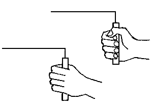
Dowsing is a type of divination employed in attempts to locate ground water, buried metals or ores, gemstones, Oil grave sites and many other objects and materials, as well as so-called currents of earth radiation (Ley lines), without the use of scientific apparatus. Dowsing is also known as divining (especially in reference to interpretation of results), or (when searching specifically for water) water finding, water witching or water dowsing.
A pendulum of crystal, metal or other materials suspended on a chain or Dowsing Rods are used in divination and dowsing. The person holding the pendulum aims to hold it as steadily as possible over the center and its movements are held to indicate answers to the questions.
Specifically, dowsing could be explained in terms of sensory cues, expectancy effects and probability.
Dowsing apparatus has no power of its own but merely amplifies slight movements of the hands caused by a phenomenon known as the ideomotor effect: people’s subconscious minds may influence their bodies without their consciously deciding to take action. This would make the dowsing rods a conduit for the diviner’s subconscious knowledge or perception; these abilities may be explained by postulating human sensitivity to small magnetic field gradient changes.
During the Water Finding Survey our experts study on the basic vital aspects which are as follows –
a) Average Rain Fall of the Area.
The climate of Andhra Pardesh is referred as Agro-Climatic zones.
The North Eastern Coastal zone receives normal or more than 1200mm of annual Rainfall. The State receives about 66% of rainfall from south-west monsoon (June-September) and about 25% from north-east monsoon (October-December). The remaining 9% is received during winter and summer months.
b) Geological situation of the plot i.e. vertical height of plot from actual Sea level & horizontal distance, to
avoid sea water intrusion into the Dug Well and shallow borewell for maintaining the required water quality & quantity.
The depth of the Borewell is limited, by considering the MSL of the region the average drilling depth & the saturation level with respect to the quality of rocks & can be ascertained; there are number of Creeks dissecting the area which protrudes in the main land and give rise to the mud flangs and swamps.
c) Natural Growth of vegetation in & around the plot, for knowing the ‘Natural Gravity Belt’ in the plot.
The earth being stamped by feet emits a loud sound; Various ecological and environmental interactions are mentioned as indicators of groundwater i.e. a tree united with another tree species, and morphological, physiological, and mutational features of plants and plant cover.
The occurrence of water below the surface at depths ranging from 3.43 to 171.40 m with the help of various plants and grass varieties could be known.
d) Previous records of the surrounding areas borewells.
We have been in the Water Management Industry from over four decades now, Our experts makes a study of all available information on existing wells i.e. information pertaining to the drilling and construction of wells would be the main sources of information, depth. thickness. and description of rock formations penetrated: water level variations as successive strata are penetrated; yields from water-bearing formations penetrated and the corresponding draw downs; the form of well construction; and the yield and draw down of the well upon completion. variations in yield and water quality and a history of any problems associated with the well since its completion.
The Groundwater in the coastal alluvium of Andhra Pradesh occurs both under water table and confined conditions and is generally developed by means of dug-wells, filter points and shallow tube wells. The depth to water table in dug wells varies from near surface to about 5 m bgl. Usually the quality of water is the main problem in coastal alluvium. Fresh water bodies occur as pockets and lenses in the top 20 m bgl. Deeper wells can lead to up-conning of salt water and fresh water interface, which can damage the groundwater irretrievably.
After considering the above given four aspects; to maintain the Quality & to achieve the targeted water quantity for the project & for all secondary use, a Test Borewell must be carried out at the appropriate location recommended in your premises by Water Finding Survey to develop the perfect ‘Tailor-Made’ Dug Well-cum-Shallow Borewell system as per your requirement.
We have undertaken various Result Oriented ‘Turn-Key’ projects for various farmers, Industries, Infrastructure companies etc. for making management of Ground Water Resources from 1 lakh Litres to 15 Lakh Litres of Ground Water per day for their various needs.
Ramblings on water divining/dowsing/witching
If I was able to find groundwater reliably I would offer to do so, for a reasonable fee. I would agree to pay the cost of drilling should the well fail, knowing that it would not fail. Any person in this position could become very wealthy if he/she had even fair business acumen. Why are there no millionaire professional water diviners?
We think of ourselves as rational beings, but at this time when science has reached enormous heights, so called ‘new age’ beliefs are rife and most of the old superstitions are still active in some minority or another. Many people believe that a successful site for a well can be chosen by a gifted person walking over the land with a ‘divining rod’. Belief in astrology and in the efficacy of many forms of medicine not supported by valid evidence is common. Water divining is just another superstition; a belief not supported by evidence.
Written about September 2001; placed on its own page 2004/02/25; modified 2011/04/22
Feedback welcome, email daveclarkecb@yahoo.com
Introduction
The self-deception of being able to locate groundwater (underground water) by walking over the ground with either a forked stick, one or two bent wires, or a pendulum is generally called water divining in Australia and water dowsing or water witching in the USA. It is a superstition that many people do not recognize as such.
The sketch of the diviner on the right is from James Randi’s excellent page on divining.
What makes me believe that it doesn’t work?
I have worked in the groundwater field for about thirty years. I have never seen or heard of a convincing demonstration of divining.
I have read of many scientifically conducted studies into divining. I have never read one that indicated that it worked.
Groundwater is very common, almost ubiquitous. For example clays can contain up to 50% water, although they will not yield a significant amount to a well. Do divining rods discriminate between water contained in clays and water contained in sands, gravels, and fractured rocks?
Diviners usually talk of finding narrow underground streams. In most geological settings these do not exist. The many diviners that I have talked to seem to believe that these streams are less than a metre wide and are spaced every hundred metres or so across the landscape. If this were true, then in my work locating well sites, because I ignore these ‘streams’, my success rate in selecting well sites would be less than one percent; however it is more like 40%. (I most often select well sites in the Australian desert.)
There are only four known forces in nature: electromagnetism, gravity, the strong and weak nuclear forces. Of these, only the first two are significant over the distances people usually deal with. (The force exerted by wind or water currents is due to the electromagnetic forces between the electrons ‘attached’ to the molecules of the fluids and those of the body they are interacting with. A similar thing applies when one solid body presses against another: the force comes from negatively charged electrons reacting against each other.) Scientific instruments are much better at measuring these forces than are unassisted people. Why can’t any instruments measure the ‘force’ that the diviner claims to feel? In all other fields Man has been able to produce instruments that are more sensitive and more reliable than the Human sense of feel.
The Australian Skeptics Association has a standing US$10 000 prize for anyone who can demonstrate that they can effectively divine water beneath the ground. No-one has ever claimed the prize, although many have been tested after agreeing to the terms of the test. (The Australian Skeptics Web site referred to above also mentions a prize of $40 000, but seems unclear about whether this was a once only, or a standing offer.)
The James Randi Eductional Foundation has a “One Million Dollar Paranormal Challenge” “to anyone who can show, under proper observing conditions, evidence of any paranormal, supernatural, or occult power or event”. I believe that this includes water divining/dowsing/witching, but I am not sure on this point.
Then there is the old saying; “If you’re so smart, why aren’t you rich”. If I could reliably divine groundwater I could be a very rich man. I’m sure numerous diviners are just as clever as I am, many would be more clever; why haven’t they taken advantage of their skill? As an example, suppose a new mining town requires a water supply in a difficult groundwater area. If I had the skill I could contract to select sites at $2000 for each successful one, while I would pay the drilling costs for any failed wells. The mining company would be foolish to not accept my offer, and I could not fail.
Wells drilled on divined sites have a poorer success rate than when the sites have been selected by rational means. See divining success rate below.
There are no skills that come naturally to us and do not need training and practice; are we to believe that divining is unique in this way? We cannot walk, swim, garden, hunt, work wood, work steel, even dig a hole in the ground without learning how. Yet diviners, we are told, just have the ‘knack’?
Recommended Internet sites on this subject are:
James Randi and
The Skeptics Dictionary by Robert Todd Carroll. Carroll discusses the Scheune or barn test which some claim proves that there is some scientific validity in divining.
Other questions and curiosities…
Does the ‘force’ diviners feel only propagate vertically? Why should it? Why shouldn’t it propagate at 45 degrees from the vertical in some places and 60 degrees in others; or in different directions at different times? How can anyone know how it propagates? Yet, in my experience, all diviners assume it propagates vertically.
I met a man who claimed to be able to divine for both precious opals and water. He said that the rods worked for opals in country where you would expect opals and worked for water where you would expect water. I find this incredible. Groundwater can be found almost anywhere, I have supervised the drilling of water wells in the opal mining country where this man divined for opals. (Opals are a form of silica, which is one of the most common substances in the earth’s crust. How does the divining rod discriminate between opal and other form of silica?) I think it was Pliny who recorded that some people believed they could divine for metals. How do these people learn to discriminate between – for example – water, iron, and aluminium, all of which occur almost everywhere. (Presumably divining rods didn’t respond to aluminium until it was discovered. It is now known to be the third most common element in the Earth’s crust.)
There are so many different methods of divining. Some people use a forked stick, some use ‘L’ shaped wires, some (mainly in the USA?) use a pendulum. Some claim to be able to divine over a map – they don’t even need to go to the land where the water supply is required.
Some people claim to be able to differentiate between fresh and saline groundwater. Yet how did they learn to recognize a salt stream and a fresh stream? Did they attend a water divining school where they were taken over a known salt stream at one place and a fresh stream at another place so that they could learn the difference? Or is it just some sort of ‘gut feeling’?
Others claim to be able to detect moving water, but not still water; apparently they don’t know how very slowly most groundwater moves.
One man who claimed to have the gift explained why diviners are never rich with the theory that when any diviner asks money for using his power he looses the power. What a wonderful explanation!
Home
Top
Index
Some errors of diviners
I believe the following may be of interest as examples of errors that I have heard from those who believe in divining.
• Any diviner can find a water pipe. In fact tests such as those conducted by the Australian Skeptics show that diviners cannot detect water pipes.
• A diviner told me that he detected two streams that cross each other. I asked him if they were at different depths. He said no, the same depth. How does one stream cross another? Can the reader imagine one surface stream (river, creek) crossing another?
Extracts from Geological Survey of South Australia Bulletin No. 23, 1946
Some divining history
From R.W. Raymond in a paper contained in the transactions of the American Institute of Mining Engineers, 1883, and in United States Geological Survey Mineral Resources, 1882, wrote of divining and diviners as follows:
"The Scythians, Persians, and Medes used them. Herodotus says that the Scythians detected perjurers by means of rods. The word rhabdomancy, originated by the Greeks, shows that they practiced this art; and the magic power of Minerva, Circe, and Hermes or Mercury is familiar to classical students. The lituus of the Romans, with which the augurs divined, was apparently an arched rod. Cicero who had himself been an augur says, in his treatise on divination, that he does not see how two augurs, meeting in the street, could look each other in the face without laughing. At the end of the first book of this treatise he quotes a couplet from the old Latin poet Ennius, representing a person from whom a diviner had demanded a fee as replying to this demand ‘I will pay you out of the treasures which you enable me to find.’
Marco Polo reports the use of rods or arrows for divination throughout the Orient, and a later traveller describes it among the Turks. Tacitus says that the ancient Germans used for this purpose branches of fruit trees. One of their tribes, the Frisians, employed rods in church to detect murderers. Finally, if we may trust Gonzalez de Mendoza, the Chinese, who seem to have had everything before anybody else, used pieces of wood for divination.
Divining success rate: A major study in NSW, Australia
"There is no body of evidence, so far as the writer is aware, so valuable for assessing the claims of divining as that which has been gathered and recorded by the Water Conservation and Irrigation Commission of New South Wales in connection with the shallow drilling carried out for settlers in central New South Wales. The drills are operated by the Commission, and the drill foreman has to report at the outset of the work whether or not the site has been divined. The settlers are not influenced in any way in the fixing of bore sites, and some of them have made their own selection, while others have taken the advice of diviners. From these reports the Commission has compiled in the table, which which can’t be given
The districts within which these boreholes were drilled have a yearly rainfall ranging from nearly 30in. (app. 750mm) to under 15in. (app. 375mm) in the extreme west. The northern part of the area embracing the boreholes lies largely within the Great Artesian Basin, with a consequent material reduction in the risk of failure. Yet it will be seen that the proportion of failures at divined sites is nearly double that at sites not divined, while the percentage of highly successful drillings is far greater at sites not divined than that at the divined sites. The very large number of boreholes embraced in the tabulation corrects the deficiency that has been felt by those who have tried to discuss divining in the light of the records dealing with a small number of cases, some of which may have been selected, and omitting any reference to the failures that must certainly have occurred."
End of extracts for Geological Survey of SA Bulletin
From the table above, one should perhaps call in a diviner to select a site, and then make a point of drilling somewhere else to maximize one’s chances of success!
The Matter of Dowsing
from Swift, Vol. 2, No. 3/4 January, 1999
By far the most common claim made for the Million Dollar Challenge offered by the James Randi Educational Foundation (JREF) is dowsing.
Dowsing is as strictly defined the claimed ability to discover underground sources of water or metals by means of a “dowsing rod.” Another term used is “divining.” However, this terminology and its scope have been expanded and is now used with a far greater range of meanings. Dowsing now includes the claimed ability to discover almost anything, from water and minerals to missing children and archaeological sites. Each dowser will have his or her specialty. The device any dowser will use ranges from the traditional forked stick to just the bare hand. Pendulums, bent wires, wands of various sorts, and swiveled rods and housings are commonly encountered. In every case, the device used is a system in a state of unstable equilibrium, something that cannot easily be kept in a steady condition, and which is subject to very slight tremors, twitches, or changes of inclination. We’ve seen an astonishing variety of metal springs, coils, wires, balls, threads and bobbing elastic devices, all trembling and vibrating freely, used as dowsing machinery.
• Little Agreement
• A Wide Spectrum of Claims
• The Ideomotor Effect
• A Compelling Belief
• Excuses, Excuses
In an area of lateritic soil near Hyderabad where the water table lies at around 50 feet and a possibility of sheet rock at around 150 feet depth, what would be the chances of finding good water from atop a hillock which has a height of around 50 feet?
In general, when drilling a borewell, must one always drill at the lowest point(s) within the property?
There are various factors affecting the groundwater movement in the particular area with respect to its hydrogeology & morphology.
laterite, soil layer that is rich in iron oxide and derived from a wide variety of rocks weathering under strongly oxidizing and leaching conditions. Lateritic soils may contain clay minerals; but they tend to be silica-poor, for silica is leached out by waters passing through the soil. Typical laterite is porous and claylike.
Laterite is not uniquely identified with any particular parent rock, geologic age, single method of formation, climate per se, or geographic location. It is a rock product that is a response to a set of physiochemical conditions, which include an iron-containing parent rock, a well-drained terrain, abundant moisture for hydrolysis during weathering, relatively high oxidation potential, and persistence of these conditions over thousands of years.
Question 1: what would be the chances of finding good water from atop a hillock which has a height of around 50 feet?
Answer - As you may learn from the above paragraphs that the lateritic Soil are found in a well drained terrains, with abundant moisture for hydrolysis during weathering, in such hydrogeological morphology, there may be dykes & lineaments in the area which shall have the potential confined strata for sinking a Dugwell-cum-Borewell.
Therefore, chances of finding the ground water are most likely in the Dyke Lineaments whether on the hill or on the slope of the hill, where the Laterite formation is favoured in low topographical reliefs of gentle crests and plateaus which prevents erosion of the surface cover.
Topographical Reliefs on top of the Hill, probably where a well could be sunk
Question 2: when drilling a borewell, must one always drill at the lowest point(s) within the property?
Answer - In your case, location for drilling of the borewell must be selected after observing the dyke lineaments in & around your property & with respect to the Laterite geomorphology I shall suggest for Borewell-cum-Dugwell for tapping the upper confined water aquifer through dugwell which shall augment the deep aquifer of the borewell in the confined & fractured rock formations, for fulfilling your daily requirement of water.
Please Note: - although I have just tried to sketch the scenarios for sinking a well based on your query, you may actually sink the well only after you get the Hydro-geological survey done at your property.
Traditional Groundwater Diviners/Dowsers v/s Science and technology for Groundwater Exploration- a burning problem in the world
Throughout world including India, the Groundwater diviners/dowsers claim having the special extra ordinary powers within them by which they could find out the site, for constructing/drilling the bore / wells having best yield of groundwater with definite depth and yields. Literate and illiterate villagers & farmers are highly affected by the ground water diviners. In our country, farmers and agriculture farms are mostly dependent on the unreliable and uncertain rain water through monsoon season. In this situation, the farmers try to irrigate their farms by groundwater to get other seasonal crop yield and earn. In this situation farmers try to get bore wells drilled in their farms by getting the site fixed up by groundwater diviners/dowsers or one other non-scientific methods. These situations repeat each and every where due to repeated failure but very few asks for scientific trusted method for Groundwater Exploration.
The water diviners/dowsers apply different type of methods such as, “Y” shaped thin green branch of any vegetable, cleaned up coconuts, “L” shaped two rods of any metal, “U”/ “V” shaped single rod of any metal, pendulum and other ideas produced from their mind. The man having scientific thinking and knowledge observe their funny nonscientific practices of groundwater investigation and indicate his disagreement but none of diviners and farmers support him. These diviners ever try to explain their method by their own fabricated false rules of science and misguide the farmers. Many time these diviners/dowsers get awards / certificate of excellence by some political and social leaders…and thus they are promoted to make the lot of loss of farmers and earning false credit and money also
If we describe their method, they just carry these rods or sticks and coconuts in their hand and travel in the field for few meters. And the method is, because of their believed divine power the rod or sticks will move or rotate in their hands and that means there is a stream having lot of groundwater after drilling a bore well. Sometimes they get lucky and they get good price in terms of money/kinds for this exploration but many times it fails too and farmers accept the cause of their luck. Some people have funny experiences of these groundwater diviners. Sometimes these diviners with overconfidence claim that they will repay all the cost of drilling the bore well in case of failure and when they notice that their prediction is going to be failed, they leave the site during darkness of night and will never show their face in that area. Any how they get plenty of chances to earn money. Unfortunately, some of these groundwater diviners get awards from state ministers and they use these awards to promote their fake services.
None of these groundwater diviners have any scientific explanation of their techniques, but to make such drills for bore wells, sometimes it costs Rs. 15,000-80,000 and repeating which is lot of money, the worst economic condition of these farmers.
In India, there are already many, so called Babas and Gurus who claim to have cure for diseases like Cancer, AIDS and many uncured diseases with no background of medical knowledge at all. Such water diviners could be included in the same category. Even after such a situation the farmers could not leave the Traditional Groundwater Diviners and adopt latest science and technology for groundwater exploration
For such groundwater explorations, Geophysical Survey using the Electrical Resistivity Method is a worldwide practical and economical scientific method to find out the best site of bore well drilling. This method has a success rate of near about 80%.
Unfortunately, there are very few people and organizations who can guide scientifically to explore the sites for groundwater in India. The Government organizations and groundwater department have also not reached yet to these rural farmers in India. In agriculture sector latest science and technologies are adopted. The farmers should adopt the latest science and technology for Groundwater Exploration also at the time when they are applying latest science and technology for drilling the Bore wells and lifting the groundwater out of the them.
I am aware that many of you need help in finding good site locations for bore well drilling. So it is highly recommended to contact the local hydrogeologists from private organisation or Groundwater Department of State or Central Groundwater Board experts from your region. These local geologists and experts would have enough experience and data about local aquifer systems, geology, topography, groundwater situation etc to help you better in solving your problems.
We welcome every suggestions, discussion and solution related the problem so that the end users would get sufficient qualitative water for their day to day consumption for various purposes.
Brother all the Methods you have tried are OK. But we cannot find fault in Systems. So far no device or system is there to identify the availability of water, Method of using electrodes for the resistivity of the soll in various Layers is calculated by the scientist based on the Resistivity readings… It is fact that water available in Rocky layers is only be the assured water. The water available upper layers in soil Zones are not assured and are only oozing water in the earthen Zones. Ths water is for the Open wells but not Borewells.
Come to the Point the Geologist will analyze the Fractured Zones takings into consideration os the volume of Fractures . The Geologist will think and analyse that there may be water and asses the Quantity based on the volume of Infrastructures,
Now come to the Point his assessment may fail if there is no water in the fractrucures . In those fractures there may be vacuum, air, oil etc. Taking into consideration of the above points its neither the fault of the System nor Geologist. The same thing may apply in the case of Copper plates,coconut etc.!
We are submitting based on the knowledge gathered in my service in my Department though I am neither a Scientist nor an Engineer.
MANNE.SN,
for Vasudha Green Farms (A Reliable Farming Consultants in India),
9133498366 (WAP), 7416446789
Dear Sir,
Greeting from Water and Mineral Explorer,
We have well-experienced Hydrogeologists How are worked in Rural Development of Telangana State Andhra Pradesh for Irrigation by Ground Water.
.
For Borehole point/Hydro-Geological Survey to Locate Ground Water for Bore Well by HydroGeologists-
Please Contact on 9949110706/ +919573016105.
Greeting from FalconGeosolutions, We have well-experienced Hydrogeologists who are worked in Rural Development of Telangana State & Andhra Pradesh for Irrigation by Ground Water.
I have 10 years of experience & worked in 3 international countries
I m Official member of Australian institute
of Geoscientist.
Our team members who done worked in Ground water department of Andhra Pradesh and now running Team of HydroGeologist Regards education hold Doctorate in Geology, Ph.D from Osmania University.
For every survey two Geologist will visit.
We provide Advance Hydrogeological Survey plus Computer Modelling.
If you are interested let us know.
Thanks & Regards,
FalconGeosolutions,
Hyderabad TS.
+919949110706;
+919059831101.
Note : For the booking of your slot, you need to inform us one week before.
Sir,
When we discuss regarding science and technology you are absolutely right up to the Resistivity Method for groundwater prospecting, but you are saying that Copper rods, coconut etc. also working on scientific principles for prediction of groundwater, it is 100 percent wrong even if we get groundwater by applying these dowsing methods.
We should observe and study the dowsing methods without any bias. otherwise the methods based on electrical resistivity and conductivity are much more precise and offer great spatial measurement density, which will allow relatively detailed exploration. They make it possible to detect indirect signs of the presence of water…