Hi, I am building a farmhouse on 5 acres near Hyderabad. I have planted around 120 trees, including a combination of palm, coconut, and fruit trees.
Most of the bore-wells in this region have dried up, and I am not sure how long my bore-well will run.
I am considering digging a bore-well recharge to avoid water issues in the future. I am looking for inputs/contacts from those who have recently undertaken this task.
Additionally, I am open to collaborating with others who are interested in farming. Currently, we have planted trees in 2 acres, and the rest of the land is leveled and kept empty.
Borewell recharge may or may not work when water is most required. It will work effectively when everybody around you will do the same. Encourage everyone in your locality to do rainwater harvesting using whatever technique suits them. Along with bore recharge lined pond can be a better option for storing water to use in summer. You can get subsidy for digging the pond and liner also.
Thank you for your suggestion. Most of the surrounding lands are barren, and only a few boreholes in the region are successful. Do you think there will be any private contractors who provide the end-to-end solution for building farm ponds and rainwater harvesting pits?
Rain water harvesting pits and borewell recharge can be done with the help of local labours or a excavator. For knowledge resource there are multiple videos of many individuals and organizations like Pani foundation etc on You tube. If terrain is not table kindly first understand the contour and natural flow direction of water in your land. For pond and liner search for local contractors with prior experience or contact agricultural officer of your village.
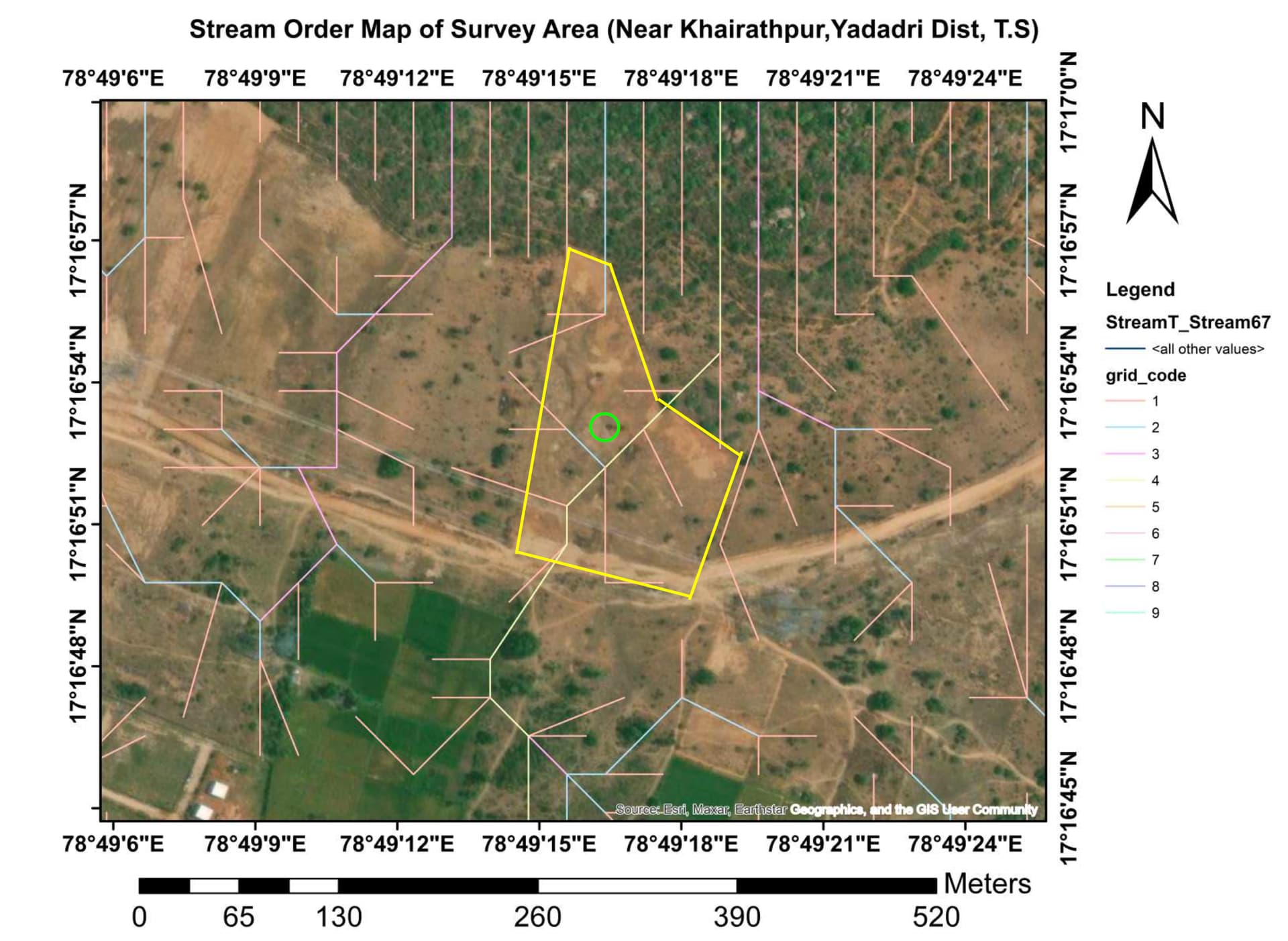
Thank you. Attached the water stream order, flowing from North to South. Borewell is highlighted in green circle.
Good decision to recharge the groundwater.
I have seen the Water Flow Map shared by you. Since the borewell is at the center of the farm(assuming) and the water is flowing from North to South, you need to have enough watershed area above the borewell point to capture the rainwater and to recharge the borewell.
Alternatively, I suggest you to do dig contour trench against the flow of the rainwater. The trenches can be of 2-3 ft wide and 2-3 ft deep and from east to west. This will ensure that the water seeps into the ground.
The trenches should be spaced every 25 ft or depending on the slope of the land.
Please keep in mind the future planting requirement in the 3 acre plot and place the trenches accordingly.
In the 2 acre plot, dig the trenches in the center between the rows of the trees and finally any excess water can be stored in the lowest/bottom most part of the land by digging a pond of your choice and depending on the excess water flowing out of your land.
In the borders of your land, you can even dig bigger trenches like 3-5 ft deep and 3-5 ft wide. Dig 10 metre long trenches in the border and give a gap of 1 metre and continue with 10 metre long trenches so that the flow of water is arrested and not carried to the lowest/bottom part of the trenches.
If you have any open well, you can measure the water table every month from now onwards and see the difference in 3 years time.
Thank You so much for your advise. There is a forest behind the property on the North and they have dig a big trench around the forest (it’s on a hill). I am thinking to wait until the first rain to see how water flows into the property then I can route that water into the pond.
There is a slope of 8 feet from N to S of the property. I could have tapped more water on the South of the property but the borewell is almost at the center of the property.
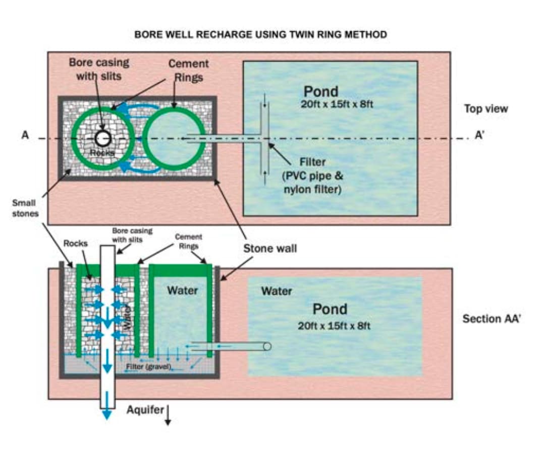
I received a response from Sankalpa organization. Attached the design that they provided.
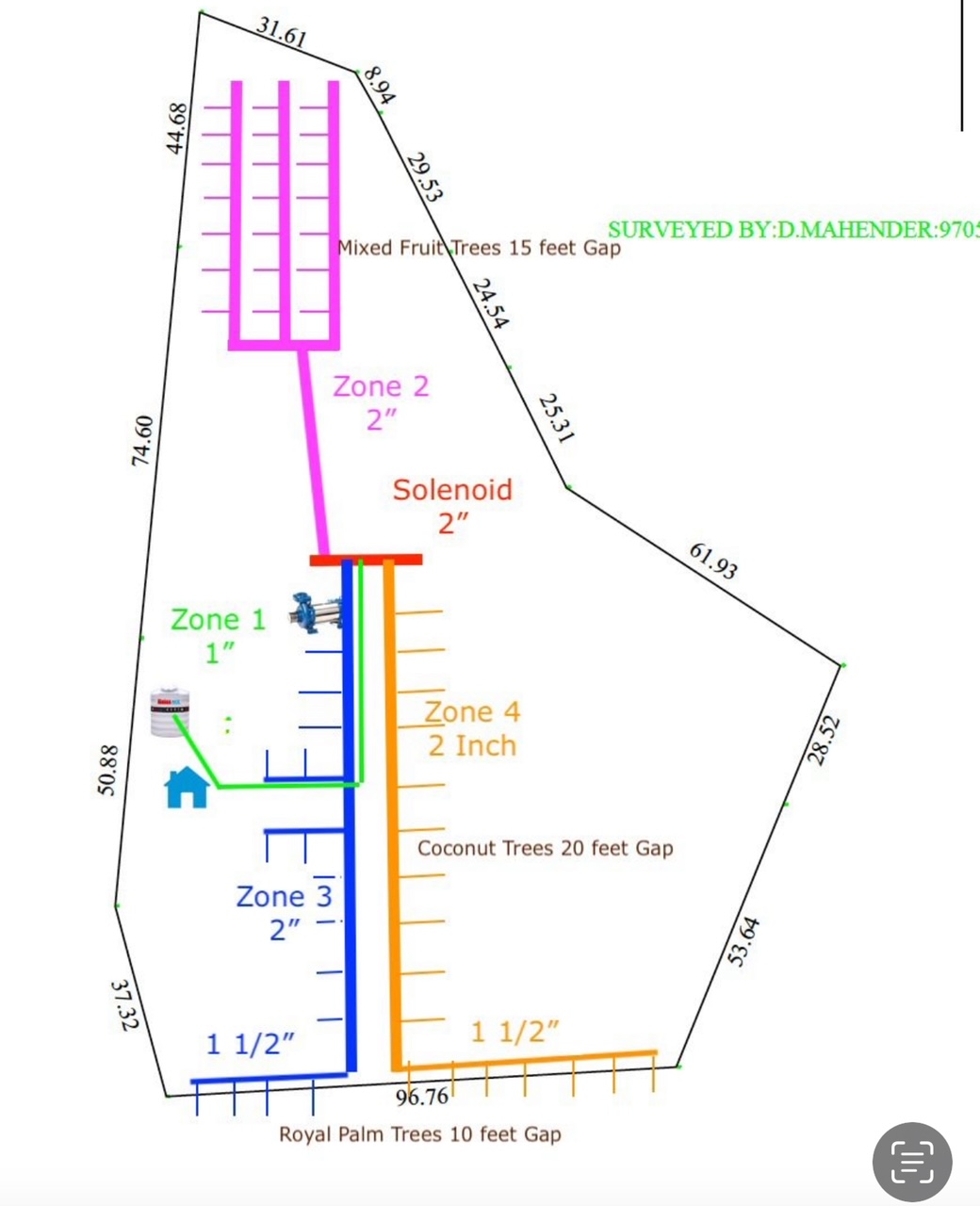
Also, Attached the farm design. Thanks to this forum. One of the member here helped me with the farm design and drip automation.
How do you get this kind of maps created? Is there some tool that automatically produces these for us?
Happy to hear this!
which map ? the farm design was done in Mac photo editor.
Manually? Or does it create the lines automatically based on the contours?
I know drip irrigation companies use some software for contouring, irrigation lines, drainage lines etc.
I did it manually on the existing Survey based on the inputs that I received from the member here.